
U.S. Atlantic Coast
Jacksonville Florida to Cape Hatteras
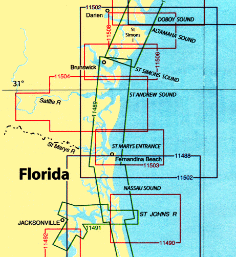
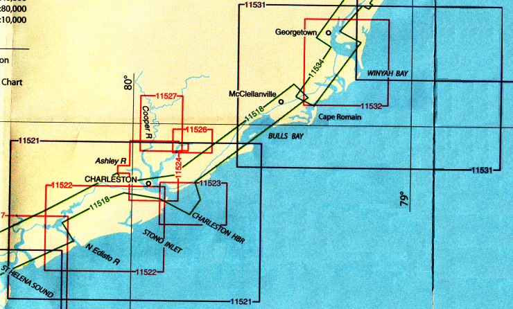
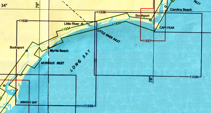
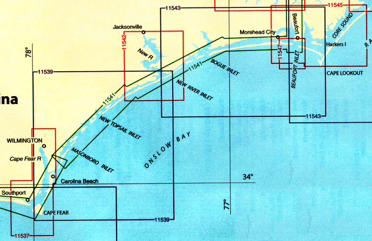
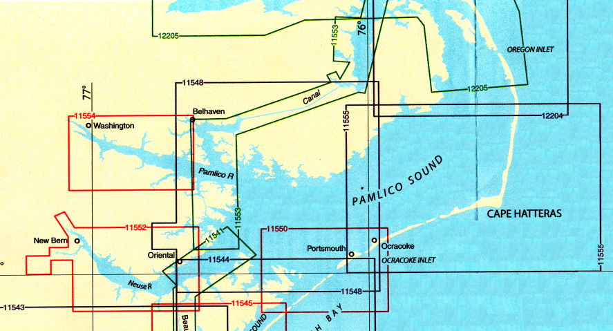
Chart List, & Enlarged View
See bottom of page for ordering information
All NOAA Nautical Charts are $20.75 each
| Qty |
Chart # |
Description |
Scale |
|
11488 |
Amelia Island to St Augustine |
1:80,000
|
|
11489 |
Intercoastal Waterway, St. Simons Sound to Tolomato River |
1:40,000
|
|
11490 |
Approaches to St Johns River
St. Johns River Entrance |
1:40,000
15,000
|
|
11491 |
St John's River, Atlantic Ocean to Jacksonville |
1:20,000
|
|
11492 |
St. John's River, Jacksonville to Crescent Lake |
1:40,000
|
|
11502 |
Doboy Sound to Fernandina |
1:80,000
|
|
11503 |
St Marys Entrance |
1:25,000
|
|
11504 |
St Andrew Sound and Satilla River |
1:40,000
|
|
11505 |
Savanah River Approach |
1:40,000
|
|
11506 |
St Simon Sound-Brunswick Harbor and Turtle River |
1:40,000
|
|
11507 |
Intercoastal Waterway, Beaufort River to St Simons Sound |
1:40,000
|
|
11508 |
Altamaha Sound |
1:40,000
|
| Qty |
Chart # |
Description |
Scale |
|
11509 |
Tybee Island to Doboy Sound |
1:80,000
|
|
11510 |
Sapelo and Doboy Sounds |
1:40,000
|
|
11511 |
Ossabaw and St Catherines Sounds |
1:40,000
|
|
11512 |
Savannah River and Wassaw Sound |
1:40,000
|
|
11513 |
St Helena Sound to Savannah River |
1:80,000
|
|
11514 |
Savananah River, Savannah to Brier Creek |
1:20,000
|
|
11515 |
Savananah River, Brier Creek to Augusta |
1:20,000
|
|
11516 |
Port Royal Sound |
1:40,000
|
|
11517 |
St Helena Sound |
1:40,000
|
|
11518 |
Intercoastal Waterway, Casino Creek to Beaufort River |
1:40,000
|
|
11519 |
Parts of Coosaw and Broad Rivers |
1:40,000
|

| Qty |
Chart # |
Description |
Scale |
|
11539 |
New River Inlet to Cape Fear |
1:80,000
|
|
11541 |
Intercoastal Waterway, Neuse River to Myrtle Grove Sound |
1:40,000
|
|
11542 |
New River
Jacksonville |
1:40,000
1:10,000
|
|
11543 |
Cape Lookout to New River |
1:80,000
|
|
11544 |
Portsmouth Island to Beaufort |
1:80,000
|
|
11545 |
Beaufort Inlet to Part of Care Sound
Lookout Bight |
1:40,000
1:20,000
|
|
11547 |
Morehead City Harbor |
1:15,000
|
| Qty |
Chart # |
Description |
Scale |
|
11548 |
Pamlico Sound- Western Part |
1:80,000
|
|
11550 |
Ocracoke Inlet and Part of Care Sound |
1:40,000
|
|
11552 |
Neuse River and Upper part of Bay River |
1:40,000
|
|
11553-PF |
Intercoastal Waterway, Albemarle Sound to Neuse River
Alligator River
Second Creek |
1:40,000
1:80,000
1:80,000
|
|
11554 |
Pamlico River |
1:40,000
|
|
11555 |
Cape Hatteras- Wimble Shoals to Ocracoke Inlet |
1:80,000
|
|
12204 |
Currituck Beach Light to Wimble Shoals |
1:80,000
|
|
12205-SC |
Cape Henry to Pamlico Sound SC Folio
Including Albemarle Sound
Rudee Heights |
1:10,000
1:80,000
1:10,000
|
All NOAA Nautical Charts are $20.75 each
Other NOAA and DMA Publications
Now Available

Print on Demand Charts
Please Note:
With all the recent cases of on-line credit card and Identity theft,
we feel obliged to inform our customers that neither
C.G. Edwards Co Inc. or Boxell's Chandlery,
under any circumstance sell or divulge any personal information about our customers,
nor do we in any way store confidential information on our server.
Please be assured that we will continue to do everything within our power to keep any
information submitted by our customers as secure as we possibly can.
|
| Please select the products and/or enter the number of units required. On JavaScript-enabled browsers the display table will be automatically updated. Such display is for information only and is not essential for the operation. You can select any number of items prior to adding to the shopping cart. It is not necessary to add each item to the cart as they are selected. However, if the products are in the form of a simple or dropdown list, and JavaScript is NOT enabled, then you must add each item to the cart individually.
|
 Boxell's Chandlery